Hilary McMillan
San Diego State University
Projects
-
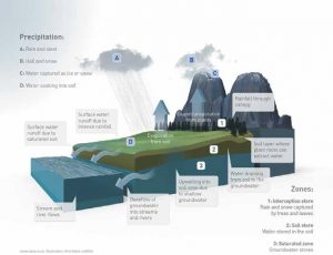
This project, titled “Synthesizing hydrologic process knowledge to determine global drivers of dominant processes” is supported by a 3-year, $376,000 grant from the National Science Foundation (NSF) Hydrologic Sciences Program to bring together hydrologic process knowledge from intensively-studies watersheds across the globe. A fundamental challenge in hydrology is to explain where and when different hydrologic processes occur, and how they are controlled by climate and landscape. Hydrologic processes describe how water moves through and is stored within the landscape on its path from rainfall or snowfall to river flow. Large-scale process knowledge is valuable for a wide range of applications such as designing realistic and accurate flow forecasting models, and choosing effective interventions to improve water quality. Many scientific organizations maintain intensively monitored watersheds that provide deep understanding of hydrologic processes at specific locations, but the knowledge is fragmented and difficult to integrate across regions and continents. This project will unify field hydrology studies into a global picture, by creating and exploring a searchable database of hydrologic process knowledge. We Will populate the database with extensive knowledge from hundreds of experimental watersheds, using a taxonomy of hydrologic processes to enable labeling, organizing and hierarchical searching for process information. We will explore the database to synthesize global patterns of hydrologic function, to analyze how dominant processes can be explained by physical watershed features, and to reveal transitions in processes at events and seasonal timescales. We will apply the database to evaluate new generation continental-domain hydrologic models, which currently lack the process data needed to select model structure. They will test whether flow predictions improve when models accurately represent processes, and whether model sensitivity analysis identifies the same dominant processes as those found experimentally. The long-term vision for the database includes a role as ‘ground truth’ for future far-reaching machine learning efforts such as automatic literature and data analysis for process prediction.
-
Dr Hilary McMillan has received a 3-year, $295,000 grant from the National Science Foundation (NSF) Hydrologic Sciences Program to support her research on how landscape features influence the hydrologic cycle. The new project, titled “A framework to predict hydrologic processes at continental scales” will predict how watershed processes vary across the U.S.. The project develops a new approach that combines small-scale field hydrology knowledge within a continental-scale, machine learning application, and aims to discover new relationships between landscape features, streamflow dynamics and watershed processes. This information is essential to building accurate hydrologic models and making reliable predictions of streamflow, floods and droughts. Dr McMillan will partner with NOAA’s National Water Center to apply the results in the design of the Next-Generation U.S. National Water Model. The project will develop online learning materials on the topic of continental-scale hydrology, and will offer research opportunities to PhD, Masters and Undergraduate students at San Diego State University.
-
Dr Hilary McMillan has received a 3-year, $293,846 grant from the National Oceanic and Atmospheric Administration (NOAA) Marine Debris Program to support her research on how plastic and other debris enters and is transported from the San Diego River to the ocean. The new project, titled “Missing the main load? Quantifying marine debris loadings from storm drain and river margin sources in the San Diego River” includes five co-PIs from the SDSU Blue Gold Area of Excellence. The project team will conduct field, laboratory, and modeling studies to understand the sources and amounts of marine debris entering the San Diego River watershed. Using new and existing data and remote sensing techniques, the researchers will develop a model for the watershed to compare inputs of debris from river margin sources, including encampments and illegal dumping, with debris from storm drain outfalls. The project will also interview unhoused individuals to determine the drivers of debris-generating behavior and develop strategies to reduce debris from encampments.
See NOAA’s announcement of the funded projects here:
-
Dr Hilary McMillan, with co-PIs Jasper Oshun (Humboldt State) and Amelia Vankeuren (CSU Sacramento) has received a 3-year, $314,251 grant from the National Science Foundation (NSF) Geopaths Program to support undergraduate hydrology research training. The new project, titled “Developing a diverse hydrology workforce through an undergraduate hydrological research experience in a coastal California watershed” will recruit cohorts of students from San Diego State University, Sacramento State University, and Humboldt State University, all of which are minority serving institutions. The recruitment plan includes leveraging existing programs at each campus that engage students from diverse backgrounds in STEM disciplines. Students will participate in the experience in three stages: (1) Spring research preparation seminar series and cross-CSU webinars, (2) Intensive 10-day summer field experience with a cross-CSU cohort, and (3) Fall class for a sustained learning experience and presentation of results at a regional conference. Student research will be organized around three research themes: (1) Water held within and moving through the critical zone, (2) Water quality and aquatic habitat, and (3) Scaling up and human effects. Planned outcomes include development of research and professional skills, increased identities as members of the geoscience community, and increased student retention in the geosciences.
-
Hydrologic alteration (i.e., change in streamflow patterns) is a pervasive issue across southern California and is a threat to the biology and ecology of river ecosystems. It occurs due to short- and long-term changes in climate, land use, and water management. In this project, Dr McMillan and PhD student Donny Kim will work with scientists at SCCWRP (Southern California Coastal Water Research Project) to help provide detailed information on why flow changes occur, by using machine learning to link watershed changes to functional flow metrics (metrics that describe aspects of flow dynamics relevant to benthic habitat). The results will provide information for future management decisions to help preserve stream environments.
-
Hilary collaborates with UC San Diego on a project funded by the National Oceanic and Atmospheric Administration (NOAA) to improve predictions of rapid snowmelt caused by Atmospheric River storm events in the Sierra Nevada and Cascade mountains. The results will be used to improve the performance of the National Water Model, a US-wide hydrologic model developed by the National Water Center.
This research has three main parts. (1) To assess the physical processes and parameters linked to rapid snowmelt in the NWM/Noah Land Surface Model, using machine learning to diagnose opportunities for improvement (2) Provide recommendations to the NWC on improvements to snowmelt-related calibration parameters in the NWM. (3) To develop a situational awareness tool that will identify potential extreme snowmelt conditions of interest to hydrologic forecasters.
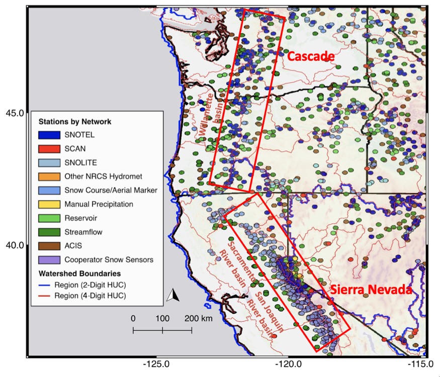
Figure 1 Study area, and snow network data (collected by Natural Resources Conservation Service (NRCS)).
-
Hilary has partnered with the Center for Western Weather and Water Extremes led by Scripps Institution of Oceanography, as part of their Forecast Informed Reservoir Operations (FIRO) project.
The goal of FIRO is to develop, demonstrate, and implement tools and science that enable more effective management of reservoirs by leveraging improvements in weather and water forecasts. FIRO began work with Lake Mendocino, and is now extending to Prado Dam and Yuba/Feather. FIRO has already enabled changes to the USACE operating rules of Lake Mendocino that enable more water to be reserved for summer use, without increasing flood risk. Hilary’s role is to provide technical leadership for hydrologic modelling research at CW3E.
Hilary attended the 6th FIRO workshop in August 2019.
-
Hilary was a Theme Leader at the CUAHSI National Water Center Innovators Program Summer Institute, for the theme “Scaling hydrologic and hydraulic models from small basins to regional watersheds”. Students in the theme, including PhD student Donny Kim from Hilary’s research group, worked on trialing alternative hydrologic model structures in the National Water Model.
The Summer Institute is a unique program which brings together graduate students, academic researchers, and National Water Center staff to work on projects designed to improve water-related products and decision-support services. Since the first Summer Institute in 2015, over 100 hundred students have participated in the program, which continues to play an important role in developing and refining the National Water Model.
See more details here: https://www.cuahsi.org/education/summerinstitute/
-
Hilary was recently awarded SDSU University Grants Program funding to measure and analyze the hydrologic, landscape morphology, and land-use factors that determine flood magnitude differences between San Diego river canyons. Flood magnitudes are a key driver of coastal water quality deterioration in Southern California, and differ strongly between canyons despite superficially similar urban watersheds. Because the cause of the differences is unknown, governing agencies cannot create long-lasting policy to mitigate polluting areas.
The project involves a field study using longitudinal surveys of river flows and stable water isotopes in San Diego canyons to relate urban morphology to changes in flow paths and flow magnitudes. This will include using Particle Image Velocimetry to advance large-scale mapping of urban river flows. Click here for a short video about the PIV work we are doing.
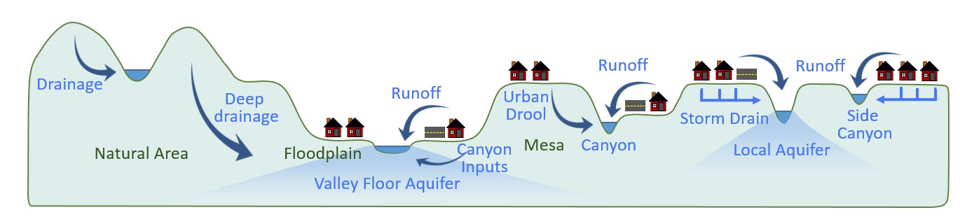
Figure: Schematic diagram of hypothesized water flow paths in an urban, canyon-mesa landscape. This study will use flow measurement and tracer methods to establish which flow paths are dominant and how flood flows are controlled by landscape morphology and urban form
-
Urban agriculture is popular as a way to re-green our city landscapes and stem environmental degradation caused by industrial agriculture. However, local ecosystems and their capacity to support agriculture are highly variable, for example, urban agriculture competes for irrigation water in arid or semi-arid areas. This project will quantify and compare the environmental pressures generated by urban agriculture (e.g., water, fertilizer and pesticide use) and the environmental benefits (green space, soil productivity, biodiversity, and water conservation).
The project will use a variety of urban agriculture locations in San Diego, to investigate how location, garden mission, agricultural practices and socio-economic context, all change the ecosystem services and pressures of the urban agriculture site. Our aim is to understand how best practices can maximize the environmental benefits and productivity of urban agriculture.
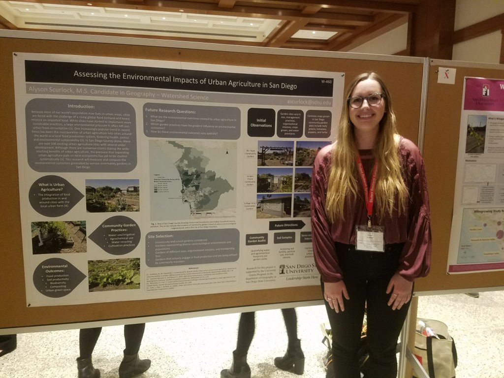
Figure: MS student Alyson Scurlock presents her research into urban agriculture at the SDSU 2018 Student Research Symposium
-
Industrial associations in San Diego County must achieve compliance with the new Draft Industrial General Permit by capture and retention of 85% stormwater on their sites. Students are helping to identify the number of larger-scale industrial sites within the region that have the ability to store a large quantity of stormwater on site, identify how the water could be used and then quantify the amount of potentially stored stormwater.
This project is organized as a partnership with the San Diego County Water Authority, providing students with experience of professional hydrology careers.
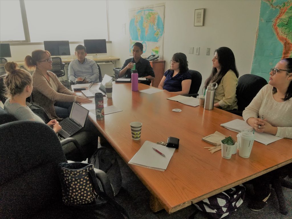
Students meeting with San Diego County Water Authority staff to design the project scope and goals
-
Groundwater in the Mission Valley aquifer in San Diego is sourced both from rainfall on adjacent hillslopes, and from channel transmission losses. In this project for the City of San Diego, we are working to quantify the relative importance of those two sources. We aim to understand how and where different waters flow into and through the San Diego River watershed, and to differentiate between surface (river) and rain waters entering the Mission Valley aquifer.
We are using stable isotopes of water, including oxygen and deuterium, which can be used to identify sources of recharge to groundwater systems. Isotope “fingerprints” of rainwater, stream baseflow (low flow) and stormwater will be used to differentiate between these waters. Because isotopic composition of stream water can vary significantly during storm events, we are installing auto-samplers to take water samples at multiple time points during the storm hydrograph, to completely characterize the stormflow isotopic composition.
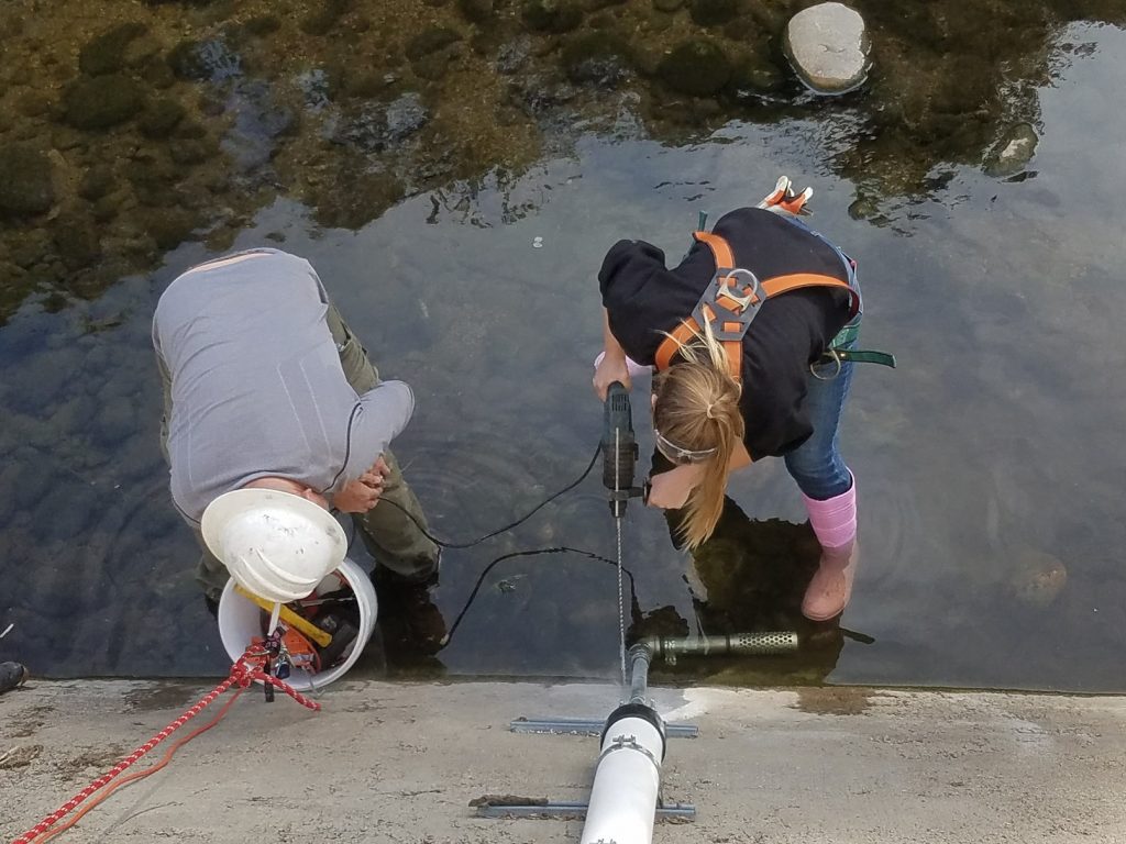
Figure: Pablo Bryant (Field Reserve Manager) and Sierra Wallace (MS Student) installing an autosampler location in a tributary of the San Diego River
-
From 2015-2017, I was Chair of the IAHS hydrological decade 2013-2022 with the theme `Panta Rhei: Change in Hydrology and Society’. The decade recognises the urgency of hydrological research to understand and predict the interactions of society and water, to support sustainable water resource use under changing climatic and environmental conditions. For 2021-2022 I am part of the leadership team for the final biennium of Panta Rhei.
-
I led the instrumentation of an experimental catchment in the Canterbury high country in the NZ South Island, to study catchment processes in upland environments. These upland environments are essential to provide water via streams and groundwater flows to the agricultural areas on the coastal plains downstream.
We installed a climate station, rain gauges, flow gauges, deep wells, tensiometers, sap flow sensors and nests of instruments including soil moisture sensors and shallow groundwater wells. Isotope sampling was used to track water sources for vegetation and streamflow.
Results of the study were published in HESS: “Characteristics and controls of variability in soil moisture and groundwater in a headwater catchment“.
-
I led a team of scientists at the National Institute of Water and Atmospheric Research (NIWA), NZ, to provide operational flood forecasts for rivers around New Zealand. Forecast users include local government emergency managers and hydro-electric power companies.
The project involved coupling Numerical Weather Prediction model forecasts to rainfall-runoff models to provide flood forecasts; including the use of Kalman filters for assimilation of discharge measurements to correct model states.
Ongoing work includes using ultra-high resolution weather forecasts and extension of the flood forecasting system to all catchments (gauged and ungauged) in New Zealand.
-
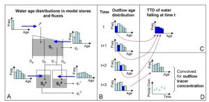
I designed a suite of hydrologic models with flexible structures that can track water, tracers and contaminants through catchment systems.
These models enable us to use tracer data as well as flow data to test hypotheses about how, where, and how fast water moves through a catchment. The flexibility of the model design enabled individual model components to be mixed and matched, to test each part independently.
The models were tested in catchments in Scotland where sea salt provides a natural tracer. Our results showed that using tracers can help us choose the best hydrologic model structure, where flow data alone cannot distinguish between the models. The results provided insight into the extensive mixing of water in soil and groundwaters that occurs even within small catchments.